|
 Right at the top of north-eastern India, crowning its six clustered sisters like a protective helmet, is Arunachal Pradesh, the 'Land of the Dawn-lit-Mountains.' This is the first Indian soil to greet the morning sun. Dawn first illuminates Arunachal's border with China: a long border which stretches all the way from its east, over to its northern boundaries and down to its north- western edge where it merges with Tibet. To its west is Bhutan and on its southern end it touches Assam, Nagaland and Burma before sweeping up to China. Right at the top of north-eastern India, crowning its six clustered sisters like a protective helmet, is Arunachal Pradesh, the 'Land of the Dawn-lit-Mountains.' This is the first Indian soil to greet the morning sun. Dawn first illuminates Arunachal's border with China: a long border which stretches all the way from its east, over to its northern boundaries and down to its north- western edge where it merges with Tibet. To its west is Bhutan and on its southern end it touches Assam, Nagaland and Burma before sweeping up to China.
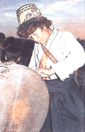
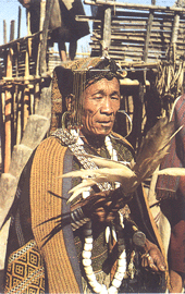
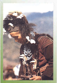
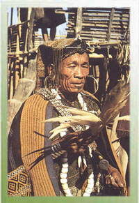
The people of Arunachal are the greatest attraction of this beautiful land. And even in the capital at Itanagar, the visitor comes across Nishi warriors wearing their 'bopiah' hornbill caps, carrying their 'chokh' bearskin bags with their 'oyjo' knives in their monkey-skin 'burkhey' scabbards. But the visitor should not be misled by their appearance. As a community's level of civilizations is judged by its health, its urge to fulfill its social responsibilities and its emotional stability, the tribal of Raunchily Pradesh are highly civilized.
General information
Population: 1,091,117
Area: 83,743
Capital: Itanagar
Languages: Hindi, Assamese, Bengali & English.
District: 13
People Per Sq: km 13
Literacy: 54.74%
Best Season: October to April
ENTRY FORMALITIES
Indians
An Inner Line Permit is required which can be obtained from the following authorities: -
The Resident Commissioner, The Liaison Officer, Govt. of Arunachal Pradesh and The Secretary (Political), Govt. of Arunachal Pradesh.
Foreigner
Restricted Area Permit is required, permits can be obtained subject to minimum 4 members in a group, from The Ministry of Home Affairs, All F.R.R.O at Calcutta, Delhi, Bombay, Madras, The Chief Immigration Officer, Madras; The commissioner Home, Govt. of Arunachal Pradesh as well as Indian Missions abroad.
Art and Handicraft
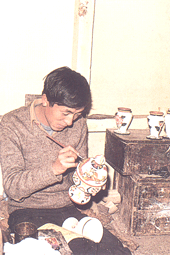
 Handicrafts Centre run by the Industries Department offers a good range of shawls, carpets, carved caskets & the beautiful cane & bamboo work in which the north-east excels. Behind & to one side of the showroom, is the workshop where cane is trimmed, cut and woven by tribal artisans with great skill. Handicrafts Centre run by the Industries Department offers a good range of shawls, carpets, carved caskets & the beautiful cane & bamboo work in which the north-east excels. Behind & to one side of the showroom, is the workshop where cane is trimmed, cut and woven by tribal artisans with great skill.
How to get there
Air
The nearest airport is Lilabari (North Lakhimpur) in Assam, 57 km from Naharlagun and 67 km from Itanagar.
Rail
The nearest railway station is Harmuty (near Banderdewa check gate) only 23 km from Naharlagun and 33 km from Itanagar. However nearest convenient railhead is North Lakhimpur in Assam, 50 km from Naharlagun and 60 km from Itanagar.
Road
Itanagar is connected by road to: Guwahati 381 km , Shillong 481 km, Agartala 980 km, Aizwal 901 km, Kohima 350 km, Imphal 495 km. Distance between Itanagar and Naharlagun is only 10 km
Places of Interest
Itanagar
The capital of Arunachal Pradesh is actually two twin towns. Naharlagan the older town, is said to have been born in 1973, and Itanagar, the official capital came up later. Though most of the administrative offices are located in Itanagar, there are some offices like the Govt. of India tourist office, in Naharlagam also. The twin town presents a very picturesque aspect and combines the old with the modern.
The Buddhist Temple
A new, but beautiful, yellow-roofed shrine, it rises in well-maintained grounds behind a stupa bearing the portrait of a monk. At one side is a tree planted by His Holiness the Dalai Lama. The grounds of the temple afford a good view of Itanagar town.
Ganga Sekhi Lake
The 6 km drive to the lake from Itanagar takes visitors on a rugged road through some superbly primeval jungles: bamboo, orchids massed on tall trees, tree-ferns are some of the vegetation which can be identified by the interested traveler. Stopping at the base of a hill, one has to cross a bamboo bridge floored with a bamboo mat spanning a culvert. This leads to a flight of steps cut into the red clay of the hill. At the top of the ridge one looks down at a serene, green forest lake, which one can cross in a rowboat. A beautiful picnic spot.
Bomdila
 Starting at the airport of Tezpur in Assam. The road passes through low wooded slops about 60 km beyond Tezpur. Anglers or those who want a brief rest should wait till they encounter the broad spread of the Bharali River as it emerges from the mountains into the wooded upper plains. On the banks of the river, at an elevation of 190 meters is Tipi, a glass house with over 7,500 orchids. From here the road is farley steep as it soars up to the small headquarter of the West Kameng district Bomdila at a height of over 2530 meters. Starting at the airport of Tezpur in Assam. The road passes through low wooded slops about 60 km beyond Tezpur. Anglers or those who want a brief rest should wait till they encounter the broad spread of the Bharali River as it emerges from the mountains into the wooded upper plains. On the banks of the river, at an elevation of 190 meters is Tipi, a glass house with over 7,500 orchids. From here the road is farley steep as it soars up to the small headquarter of the West Kameng district Bomdila at a height of over 2530 meters.
It has a tourist lodge, a Craft center, Apple orchards and Buddhist Gumphas. There are also views of Himalayan landscapes and Snow clad ranges. Bomdila is a good place to rest over nights.
How to get there
Air
Nearest airport is Tezpur 160 km
Rail
Bhalukpung (M.G) is the nearest rail station 100 km.
Road
Bus services are available from Guwahati, Tezpur, Tawang and Itanagar.
Namdapha National Park
Established in 1972, this park and tiger reserve has perhaps the widest diversity of habitats of any South Asia's protected areas. It is the only area with three major predators: the tiger, leopard and clouded leopard. The snow leopard is a possible fourth. The park' 698 sq miles
rise from 4500 m above mean sea level and the forest ranges from wet ever-green forest at the lower levels through mixed deciduous forest temperature alpine forest at the upper reaches. Three major rivers drain the area and run into the Noa-Dehing river and then the Brahmaputra. The diverse habitats and local climates hold a fascinating mix of Indo-Burmese, Indo-Chinese and Himalayan wildlife. The mammals include gaur, goral, takin, musk deer, hoolock gibbon, slow loris, binturong and red panda, apart from the major predators. Hornbills and pheasants are among the great range of birds.
How To Get
There
Air
Nearest
airport Dibrugarh 140 km is connected with Calcutta
Rail
Nearest railway station Margherita is connected
by local passenger train with Tinsukia which in turn is connected with
major cities of India.
Road
Good motorable roads connect Miao (entry point of the park) to Dibrugarh 140
km, Tezu 182 km, Sibsagar 199 km, Guwahati 561 km
ENTRY FORMALITIES
Indians
Indian tourists intended to visit Namdapha National Park need an Inner Line Permit which can be obtained from the following authorities: The Resident Commissioner, The Liaison Officer, Govt. of Arunachal Pradesh, The Inner Line Permit can also be obtained from the Secretary (Political), Govt. of Arunachal Pradesh.
Foreigner
Individual foreigner visiting Arunachal Pradesh require Restricted Area Permit from the Ministry of Home Affairs, Group tourists consisting of at least 4 (four) members can obtain the R.A.P from All F.R.R.O at Calcutta, Delhi, Bombay, Madras; Chief Immigration Officer, Madras; The commissioner Home, Govt. of Arunachal
Pradesh.
General Information
|
Altitude
|
200 meters to
4500 meters
|
|
Rainfall
|
Varies
from 2500 mm to 3500 mmVaries from 2500 mm to 3500 mm |
|
Best Season
|
October to April.
|
|
Temperature
|
Varies
between 5 to 35 at lower altitude
|
|