|
This route proceeds past the picturesque villages of Shey and Thiksey, and turns into the side-valley of Chemrey and Sakti. The Ladakh range is crossed by the Chang-la (18,000 ft / 5,475 m) which is one of the easier passes remaining open for much of the year even in winter. Tangtse, just beyond the foot of the pass, with an ancient temple and a Tourist Bungalow, is a convenient halting point on this circuit.
Pangong Lake, at an altitude of 4,267 Mt. is a narrow long
basin of inland drainage, six to seven Km. at its 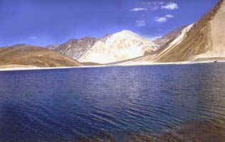 widest
point and 130 Km. long, bisected by the international border
between India and China. We can go up to seven kilometers, as
far as Spangmik village which falls on southern shore. It
affords spectacular views of mountains of Changchenmo range to
north, their reflections shimmering in the ever-changing blues
and greens of the lake's brackish waters. Above the Spangmik
are snow-capped peaks of Pangong range. The villages along the
southern shore are the summer home of a scanty population of
Chang-pa, the nomadic herds people of Tibet and south-east
Ladakh. The route passes by picturesque Shey and Thisy, turns
off the Indus valley by the side-valley of Chemrey and Sakti.
The Ladakh range is crossed by the Chang-la (5,475Mt.
which despite great height is one of the easier passes. The
major town across this pass is Tangtse, from there onwards are
various picturesque villages and hamlets. widest
point and 130 Km. long, bisected by the international border
between India and China. We can go up to seven kilometers, as
far as Spangmik village which falls on southern shore. It
affords spectacular views of mountains of Changchenmo range to
north, their reflections shimmering in the ever-changing blues
and greens of the lake's brackish waters. Above the Spangmik
are snow-capped peaks of Pangong range. The villages along the
southern shore are the summer home of a scanty population of
Chang-pa, the nomadic herds people of Tibet and south-east
Ladakh. The route passes by picturesque Shey and Thisy, turns
off the Indus valley by the side-valley of Chemrey and Sakti.
The Ladakh range is crossed by the Chang-la (5,475Mt.
which despite great height is one of the easier passes. The
major town across this pass is Tangtse, from there onwards are
various picturesque villages and hamlets.
The main attraction of this circuit is the Pangong Lake, situated at an altitude of 14,000 ft (4,267m). It is a long narrow basin of inland drainage, hardly 6 to 7 Km at its widest point, and over 130 Km long, and bisected by the international border between India and China. Spangmik, the farthest point up to which foreigners are permitted, is about 7 Km along the southern shore from the head of the lake. It presents a spectacular view of the mountains of the Chang-chenmo range to the north, their reflections shimmering in the ever-changing blues and greens of the lakes brackish waters. Above Spangmik are the glaciers and snow-capped peaks of the Pangong range. Spangmik and a scattering of other tiny villages along the lake's southern shore are the summer homes of a scanty population of Chang-pa, the nomadic herdsmen of Tibet and southeast Ladakh. The Pangong Chang-pa cultivate sparse crops of barley and peas in summer. It is in winter that they unfold their yak wool tents called rebo, and take the flocks of sheep and pashmina goats out to the distant pastures.
|
